A lot of data is missing for Germany

Good evening!
For Germany, many and significantly important data have been missing for several weeks! This is the case as of the data slice of 07.08.2023.
Thank you.
Sven

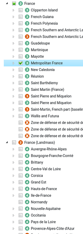
fyi: We now experience a bigger problem: France. France was always complicated but now it has a land mass as well breaking the tree more severe than all the other examples I looked at in the past.
This will result to the fact that France Metropolitaine (3) is within France (2) but all Regions (4)
are within France (Landmass) (2), but should be normally within
France Metropolitaine (3). This issue is even more severe and complicated to fix as it was with other countries because they were mostly only affecting the first child-level after the country (2) itself.
In the long run I don't see any other way than to exclude `boundary=land_area` from the country tree or only include `boundary=administrative` in the tree.
According to my tests, in the most recent dataset (`osm20240205`), the following Features are affected (at the tree top level):
|correct_osm_id|correct_name               |land_area_osm_id|land_area_name                         |
|--------------|---------------------------|----------------|---------------------------------------|
|-536,900      |Antigua and Barbuda        |-9,604,462      |Antigua and Barbuda (land mass)        |
|-52,411       |België / Belgique / Belgien|-937,244        |België / Belgique / Belgien (land mass)|
|-79,510       |Eesti                      |-4,463,372      |Eesti (land area)                      |
|-2,202,162    |France                     |-16,467,322     |France (terres)                        |
|-270,009      |Guernsey                   |-6,571,872      |Guernsey (land mass)                   |
|-367,988      |Jersey                     |-1,711,283      |Jersey (land mass)                     |
|-72,596       |Lietuva                    |-4,474,651      |Lietuva (sausuma)                      |
|-1,124,039    |Monaco                     |-36,990         |Monaco                                 |
|-49,715       |Polska                     |-936,128        |Polska (ląd)                           |
|-305,095      |قطر                        |-3,832,630      |قطر (الكتلة الأرضية)                   |
|-87,565       |South Africa               |-1,252,792      |South Africa (land mass)               |
The costline was broken in the planet.osm from that date. You can see it in the last column on the Status page. 30% of the world's land mass is gone.
Don't use that database if you care about the land mass. You can most likely use osm20240304 instead, which is newer.
Then use another database. We serve data as is in OSM. If the data is broken in OSM it's broken in our end as well. We do not spend any time to try to fix it, that would be financially impossible for us.
OSM always has broken boundary polygons somewhere, that's why there are several databases served.
See Multiple databases under https://osm-boundaries.com/Documentation .